















Oxfordshire’s countryside shapes the county’s identity, from ancient woodland to riverside meadows. It is also under pressure. Rising demand for new homes is pushing development towards village edges, transport corridors and the urban–rural fringe.
With the county experiencing rising homelessness and accommodation use in 2025, local councillors and the Government are under increasing pressure to find solutions.
Where the pressure is greatest
Greater Oxford’s housing need increasingly falls beyond the city boundary. Neighbouring districts have agreed to 7,150 affordable homes over the next 10 years to help meet unmet need, most on sites close to the city with good access to jobs and services. This moves growth into areas where the countryside begins.
What the numbers show
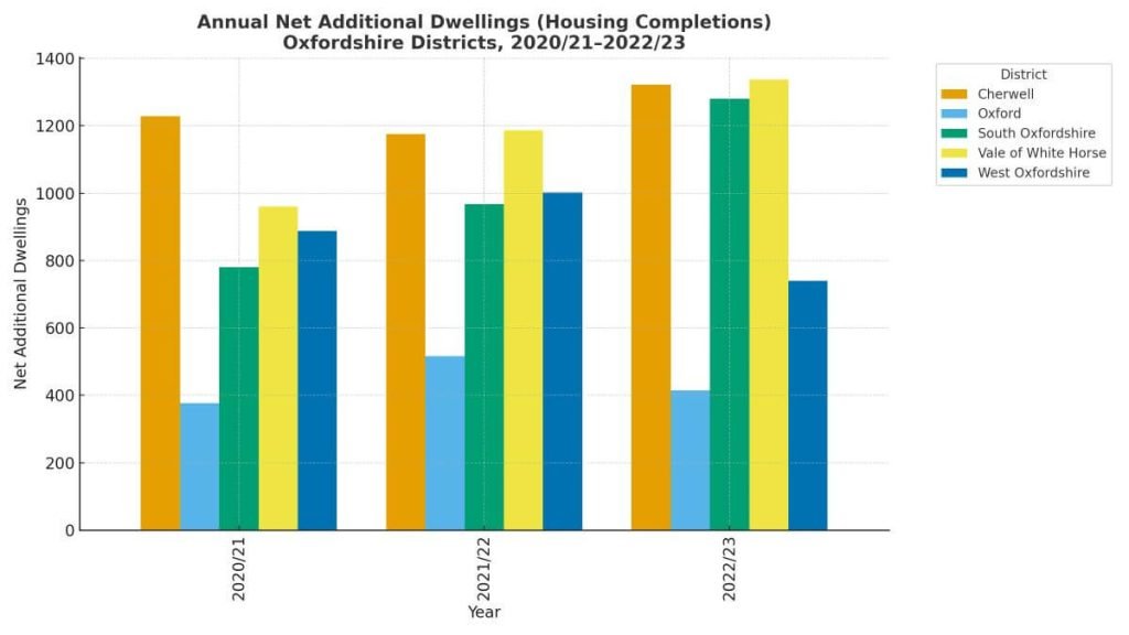
Official Government housing statistics record how many net additional dwellings are delivered each year. Across Oxfordshire, delivery rose from 4,236 homes in 2020/21 to 5,095 in 2022/23, roughly a 20 per cent increase. The district picture is below.
Annual net additional dwellings (housing completions), Oxfordshire districts
| Authority | 2020/21 | 2021/22 | 2022/23 |
|---|---|---|---|
| Cherwell | 1,229 | 1,175 | 1,322 |
| Oxford | 377 | 517 | 415 |
| South Oxfordshire | 780 | 968 | 1,280 |
| Vale of White Horse | 960 | 1,187 | 1,338 |
| West Oxfordshire | 888 | 1,002 | 740 |
| Oxfordshire (total) | 4,236 | 4,849 | 5,095 |
“Net additional dwellings” is the Government’s official measure of housing delivery. It captures the net change in homes available for use in each local authority each year. It includes:
- new-build homes
- conversions (e.g. a house split into flats)
- change of use (e.g. office to residential)
- other gains (e.g. caravans, houseboats)
- losses (e.g. demolitions, or conversions the other way)
Councils report these figures annually to DLUHC. They are the definitive measure of completions.
What the Oxfordshire table shows
- Cherwell has delivered about 1,200–1,300 homes per year, consistently high.
- Oxford City is lower at around 400–500 per year, reflecting tight land supply.
- South Oxfordshire and Vale of White Horse are both strong contributors (~1,000–1,300 per year each).
- West Oxfordshire also contributes, with a dip in 2022/23 after higher delivery the previous year.
- County total climbed from 4,236 (2020/21) to 5,095 (2022/23).
Why this matters
These completions are not just statistics, they are measured annually against the Government’s Housing Delivery Test. Oxford City has consistently fallen short of its housing requirement, triggering additional planning pressures and leaving surrounding districts to absorb unmet need. In contrast, Cherwell, South Oxfordshire, and the Vale of White Horse have generally met or exceeded their delivery test thresholds, often by releasing greenfield sites.
The fact that much of the county’s growth comes from districts outside the city, is a key tension in the countryside debate.
Oxford East Labour MP Anneliese Dodds and Oxford City Council Leader Cllr Susan Brown have previous called on the government to take the “urgent and bold action” needed to solve Oxford’s housing crisis, that is “causing misery, hardship, and stress to thousands of people in Oxford”, due to “the failure of government policy to rise to the challenges of the crisis.”
And residents also feel the strain.
“I’ve lived in South Oxfordshire all my life. My children can’t afford to buy here, and they’ve had to move further out. At the same time, we’re watching fields that we’ve walked for years being earmarked for development. It feels like we’re losing the countryside without solving the housing problem for local families.”
Amanda, Headington
What the Green Belt does here
The Oxford Green Belt was formalised in 1975 to contain sprawl and prevent towns and villages merging. It covers about 66,868 hectares, taking in land within all four surrounding districts as well as the city area. The policy aim is simple: protect openness and the setting of Oxford while allowing development where it is most appropriate.
Nationally, Green Belt coverage in England was about 1.638 million hectares as at 31 March 2023. Current policy debates include whether some lower-quality “grey belt” land should be reviewed to meet targets, alongside a stronger “brownfield-first” push.
Ian Middleton, Green councillor for Kidlington, has previously said on housing and the importance of green belt preservation and conservation:
The Green Party wants to see housing needs met, but with the right houses in the right places. We don’t want to see our green spaces gobbled up by greedy developers looking to build luxury houses on expensive land that will never be truly affordable to the local population. These developments are being driven by quangos like the Local Enterprise Partnership which are all dominated by vested interests.
“Green belt areas are not just pretty landscapes, they are also vital places that help the planet deal with the emissions being created by growth elsewhere. Concreting them over not only removes the capacity of those areas to lock up carbon, it also increases emissions, worsens local air quality and increases the likelihood of flooding.”
Brownfield first? Or greenfield release?
Environment campaigners argue that prioritising previously developed land can reduce pressure on the countryside. Recent analysis by CPRE suggests almost 1.5 million homes could be built on brownfield sites in England, with more than half already carrying some form of permission, though viability varies site by site.
Developers and planners point out that brownfield capacity is uneven, remediation can be costly, and the scale of Oxfordshire’s need still requires strategic greenfield sites alongside urban regeneration.
Case study: Didcot Garden Town
In the south of the county, Didcot Garden Town is a test of how growth and green space can co-exist. The programme plans 15,000+ new homes and around 20,000 jobs by 2031, tied to transport upgrades and green infrastructure. Supporters say it can absorb pressure for housing while protecting key landscapes; critics stress the need to deliver promised walking, cycling and public realm links at pace.
Case study: Salt Cross Garden Village (West Oxfordshire)
Near Eynsham, Salt Cross Garden Village has put climate policy at the heart of land release. Its net-zero operational carbon policy has been through a reopened examination after inspectors’ recommendations were challenged in court, a live example of how ambitious standards are being tested for deliverability and evidence.
Beyond housing: energy and land use at scale
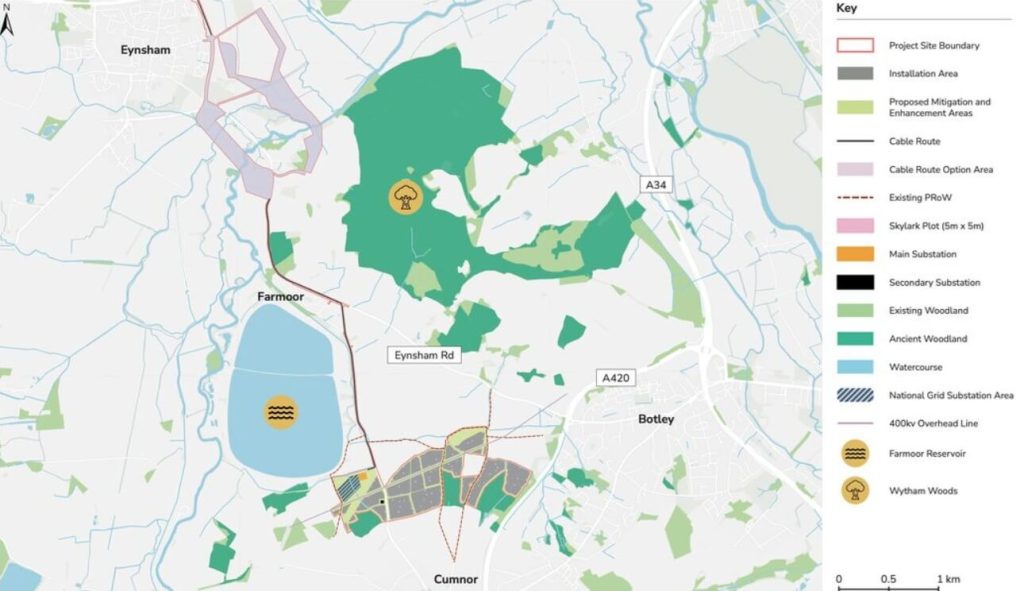
Large-scale renewables also shape the countryside debate. The proposed Botley West Solar Farm, promoted as capable of powering more than 330,000 homes with up to 840MW, has split opinion over views, farmland and biodiversity versus climate targets and energy security. Whatever the outcome, it shows how net-zero infrastructure competes for space alongside homes.
Flood risk, farming and nature
Fields, woodlands and floodplains provide natural flood management, habitat and food production. Evidence suggests nature-based measures can help reduce local peak flows and bring wider environmental benefits, though they are not a cure-all for extreme events. The policy challenge is to build in the right places, to the right standards, while strengthening these natural assets.
“We’re being asked to grow more food and look after the land, but every year more of it is taken for housing. Once good farmland is lost, it’s gone for good. The countryside isn’t just open space, it’s our workplace, it feeds people, and it helps manage floods and store carbon. That gets forgotten in the housing debate.”
Darren, a farmer from the local community
Environmental stakes
Beyond the sustainability of housing targets, Oxfordshire’s countryside underpins the county’s environmental resilience. Its soils, rivers and woodlands provide services that new infrastructure alone cannot replace.
Carbon and air quality: Trees, hedgerows and river meadows act as natural carbon sinks, storing greenhouse gases and filtering the air. Their loss to roads or housing would undermine Oxfordshire’s climate pledges.
Soil and food security: Much of the farmland in South Oxfordshire and the Vale of White Horse is classified as Grade 1 or 2, among the best in the country. Once developed, these soils are gone forever, reducing the county’s capacity to produce food locally.
Public health and access: Green space is also about people. During the pandemic, Oxfordshire residents relied on nearby fields and paths for exercise and wellbeing. Studies show access to the countryside improves mental health and reduces health inequalities, benefits that urban expansion can erode if not balanced with protection.
Together, these stakes mean the debate is not just about numbers of homes, but about the long-term health of people, land and climate.
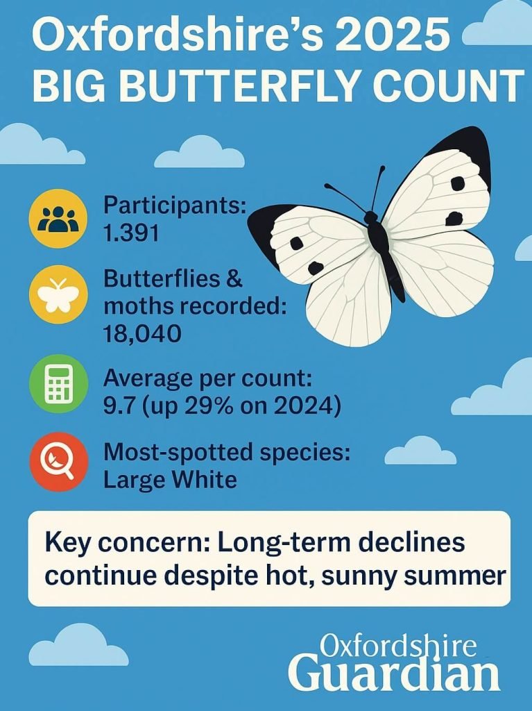
A local signal: butterflies under pressure
This summer, Oxfordshire participants recorded 18,040 butterflies and day-flying moths in the Big Butterfly Count, part of a national citizen science effort to track the key pollinators and bioindicators.
The Count is a reminder that even in good weather, many species remain under pressure. Habitat loss, pesticide use and changing land use all squeeze biodiversity, especially in rural fringes where future homes might go.
What balance looks like
For councils, the task is to meet construction need without eroding the county’s character and boundaries. That means:
- Brownfield first, where viable, with infrastructure to match.
- Strategic sites designed around public transport, cycling and walking.
- Clear Green Belt reviews only where justified by evidence and mitigations.
- Climate-ready standards that are ambitious and deliverable.
The now-abandoned Oxfordshire Plan 2050 showed how difficult it is to agree county-wide housing numbers. Councils could not reach consensus on the scale of growth, whether Oxfordshire should plan for around 100,000 or 150,000 new homes by mid-century. Its collapse highlights the tensions between meeting housing demand and protecting countryside, tensions that continue to shape local plans district by district.
For now, Oxfordshire’s countryside remains both a treasured asset and a contested space, its future shaped by choices on where, and how, we build.
Frequently Asked Questions about Oxfordshire’s Countryside and Housing
Why is Oxfordshire under so much housing pressure?
Oxford is one of the least affordable cities in the UK. Local councils have been tasked with delivering thousands of homes to meet demand, including 7,150 affordable homes agreed by neighbouring districts over the next decade. Much of this growth is planned on the city’s edges, where development meets the countryside.
What is the Oxford Green Belt and why does it matter?
The Oxford Green Belt was created in 1975 to stop urban sprawl and preserve the setting of the city. It covers about 66,800 hectares, stretching across Cherwell, South Oxfordshire, Vale of White Horse and West Oxfordshire. Its role is to keep towns and villages distinct while protecting open space.
Can all new homes in Oxfordshire be built on brownfield land?
Not entirely. National analysis suggests brownfield sites in England could host up to 1.5 million homes, but supply is uneven and remediation costs are high. Oxfordshire has some brownfield capacity, but not enough to meet full demand, meaning some greenfield release is likely alongside regeneration.
What is Didcot Garden Town?
Didcot has been designated a Garden Town, with plans for 15,000+ homes and 20,000 jobs by 2031. The project includes investment in green infrastructure, cycling and walking routes, and public spaces. It is often cited as a test of whether growth can be delivered without losing countryside character.
What is Salt Cross Garden Village?
Salt Cross is a planned settlement near Eynsham in West Oxfordshire. It is designed around high environmental standards, including a net-zero operational carbon policy. The scheme has been through legal and planning scrutiny, highlighting the challenges of balancing climate goals with viability.
What is the Botley West Solar Farm and why is it controversial?
Botley West would be the UK’s largest solar farm, spanning around 1,400 hectares on Blenheim estate land. Supporters say it could power more than 330,000 homes, helping meet climate targets. Opponents worry about farmland loss, landscape impact and biodiversity.
How does the countryside help with flooding and climate change?
Fields, woodlands and wetlands act as natural flood management systems. They can slow water flow and reduce local flood peaks, as well as store carbon and provide wildlife habitats. Campaigners argue that protecting these spaces is vital for climate resilience as well as amenity.